


Nicosia Map
- Offset Print, Full Colour
- Paper weight 115 gram.
- Size 70x100cm.
- Printed in one side.
- Items weight 138 gram.
€10,00 Including Tax 19% €11,90

Embark on a nostalgic journey through the vintage charm of North Nicosia, the largest city in Cyprus, and the last divided capital of Europe. Our meticulously crafted Illustrated Nicosia Map captures the essence of proper functioning in this Mediterranean island city, showcasing the historical and cultural treasures that define Nicosia.
Explore the thriving Republic and island country in the Eastern Mediterranean through the lens of this city map, meticulously designed to encapsulate the unique character of Nicosia. As you delve into the vintage town city plan, discover the proper functioning of the city on the free side, where the narrative unfolds amidst captivating landmarks.
North Nicosia, with its rich history and architectural wonders, takes center stage in this artistic portrayal. The map highlights the city's prominence as the largest in Nicosia Cyprus, presenting a comprehensive view of its layout, including the Renaissance Venetian wall—a symbol of proper functioning and historical significance.
Immerse yourself in the allure of this Mediterranean island as you navigate through the illustrated details of 17 monuments, 21 museums, 18 public buildings, and 16 churches and mosques. All these landmarks are intricately woven into the fabric of North Nicosia, adding to the proper functioning and cultural richness of the city.
The vintage town city plan serves as a visual guide to the city's proper functioning, inviting you to trace the pathways of this vibrant metropolis. Uncover the layers of history in Nicosia City, where every street tells a story of a divided city that has withstood the test of time on this Mediterranean island.
The map also extends its reach to South Nicosia, contributing to a holistic view of the last divided capital. The narrative continues as you explore the Republic of Cyprus, with its unique cultural heritage adding depth to the story of Nicosia.
Our Illustrated Map of Nicosia is not just a cartographic masterpiece; it's a tribute to the beauty and resilience of a city that stands as a testament to history. Whether you're a history enthusiast, a traveler seeking adventure, or someone eager to explore the nuances of Nicosia, this map is your key to unlocking the treasures of this captivating Mediterranean island city, within the context of a divided city and the Republic of Cyprus.
Related products
-
Sale!
Illustrated Panoramic Amsterdam Map - BOX 50pcs
Original price was: €500,00.€200,00Current price is: €200,00. Including Tax 19% €238,00 Add to cart -
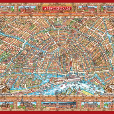
City Centre Amsterdam Map
€10,00 Including Tax 19% €11,90 Add to cart -
Sale!
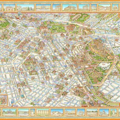
Illustrated Panoramic Athens Map - BOX 50 pcs
Original price was: €500,00.€200,00Current price is: €200,00. Including Tax 19% €238,00 Add to cart -
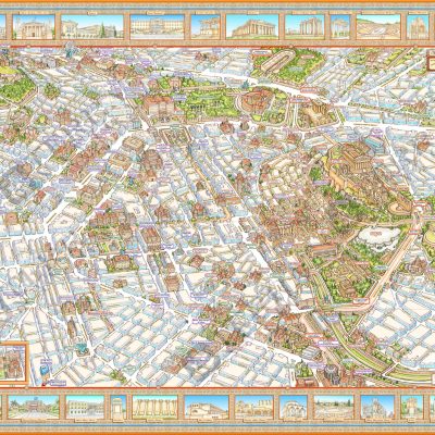
Athens Map
€10,00 Including Tax 19% €11,90 Add to cart

